1883 Poor Rate Book for the parish of St. Johns, Castlerigg and Wythburn
Download the transcript in comma separated value format RateBook.csvor in Excel format RateBook.xls
The Poor Rate derives from the Poor Laws of 1597 and 1601 which required each parish to have an Overseer of the Poor and set up the system of collecting a local tax from property owners to support those in the parish too old or infirm to support themselves.
The levy was calculated as a proportion (e.g. 6d in the £) of the notional rental value of land and buildings. It also extended to mines and quarries and to rights of access to common pasture (stints).
The Poor Rate Book was a printed ledger for recording Land, Buildings, Mines, Quarries, Tithes and Stints along with their owners and, where applicable, the occupiers, the area of land, estimated rental value, rateble value and rate due (calculated at 6d in the pound in this book).
The Poor Rate system was later extended to cover not only Poor Relief but also the upkeep of parish highways and the building of schools and the employing of teachers. i.e. it evolved from being the Poor Rate to being a general Rate, "The Rates", which will be familiar to older readers. The Rates were renamed "Community Charge" in the 1980's and is now called "Council Tax"
We are fortunate to have access (thanks to Mark Cockbain) to the Poor Rate Book for our parish for rhe year 1883.
It is not clear if these books existed for every year or if they were updated only infrequently. In any event, this is the only known rate book for our parish to have survived from the 19th century. There are a couple of twentieth century Rate bools in the National Archives at Kew.
The Poor Rate Book is arranged by township -
CASTLERIGG, ARMBOTH, NADDLE, FORNSIDE. BURNS, WANTHWAITE, WYTHBURN, LEGBERTHWAITE
Unfortunately the details of properties in Legberthwaite are missing although the total area and rateable value is included in a table of totals for each township at the end of the book...
The area of Legberthwaite is nearly twice the area of Fornside and Armboth townships and slightly larger than Naddle and Wythburn.
The overseers named in this book are John Bell and Richard Fleming and their assistant is Charles Birkett. The handwriting suggest that the entries are by the same Charles Birkett who completed the 1861 census for St johns and Wythburn. Charles Birkett was the estate manager for the Leathes family of Dalehead Hall.
Mr Birkett's ornate handwiting has led to some wrong transcriptions particularly in the case of the farm called Quey Fold, now lost beneath Thirlmere. In this Rate Book it is given in two places as Quyfold, in the 1841 census asQuayfold House, on Clarke's map of 1787 it is given as Whyfold. The Register of Crosthwaite Vol II (1600-1670) mention a place called Whytefield. which might be the same place.
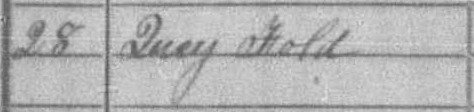 By
a misreading of Mr Birkett's ornate Q, a transcript of the 1861 census
has it as Lucy Fold (see image, left) and the LDS transcript of the 1881
census has it as Ivy Fold. For a brief period it was known as The
Parsonage (e.g. on the OS map of 1864) since the vicar lived there
pending completion of the new Parsonage nearby.
By
a misreading of Mr Birkett's ornate Q, a transcript of the 1861 census
has it as Lucy Fold (see image, left) and the LDS transcript of the 1881
census has it as Ivy Fold. For a brief period it was known as The
Parsonage (e.g. on the OS map of 1864) since the vicar lived there
pending completion of the new Parsonage nearby.The parish was a rural parish abutting the town of Keswick but in this book Keswick is shown expanding into the Castlerigg township with the building of new houses at Eskin Place and Ratliff Place (Ratcliff* Place). It is supposed that Eskin Place is built on land that was called Escambeck fields in the Manorial document of 1623. This Rate Book lists a 4½ acre field called Eskin Beck. *Ratclyffe was the family name of the Lords of the Manor from 1467 to 1716.
Commentary on land ownership as revealed by the Poor Rate Book
Manchester Corporation is the largest owner since by 1883 they own most, but not all, of the Thirlmere catchment.They don't yet own about 300 acres of Wythburn owned and farmed by John Gilbanks snr. and family, namely Stenkin, Waisthead, Pinfold Howe and Landers Intack. They don't yet own Low Horse Head.
Manchesters acquisition of Shoulthwaite gives them ownership of a substantial area outside the Thirlmere catchment namely Brown Beck Farm, Snipe How, Castlerigg Fell and Castlerigg Intack. (The reason for acquiring Shoulthwaite was that they had plans to divert the waters of Shoulthwaite Gill into the lake via a leat or tunnel).
Since the details of Legburthwaite township are unfortunately missing from the Poor Rate book it is not know how much they own there.
Owners with 2 or more farms
| Owner | Acres | Gross Rental | Ratable Value |
Manchester Corporation |
1885.181 | £1,227 | £1,103 |
| R D Marshel | 493.4813 | £933 | £846 |
| H C Marshel | 378.4813 | £401 | £359 |
| Mrs S Ann Hall | 321.95 | £352 | £314 |
| Joseph Ledger | 43.80625 | £315 | £281 |
| Countas Opsalinski | 259.075 | £296 | £267 |
| Mrs Stanger | 89.4 | £266 | £238 |
| S Z Langton | 46.30625 | £229 | £208 |
| Mr Bigland | 246.9625 | £229 | £205 |
| Capt Robinson | 179.6313 | £208 | £187 |
| Henry White | 189.75 | £193 | £174 |
| John Gillbanks snr | 269.9875 | £183 | £164 |
The next largest owners are the Marshall family who bought the Manor of Castlerigg and Derwentwater from Greenwhich Hospital.
It appears that either John Marshall, the wealthy Leeds flax manufacturer or his second son John bought the Manorship and part of the manor and his grandson Reginal Dykes Marshall inherited it. The fourth son Henry Cowper Marshall also acquired part of the manor either by inheritance or otherwise. Henry is listed in the Poor Rate Book as owning Burns farms and cottages, Yew Tree farm and cottages, Row End, Howe Gate and Bridge cottage.
Reginald Marshall owns Stable Hills, Springs Farm, Goosewell, Wanthwaite Mill, Fornside Mine and a Quarry at Wanthwaite.
Reginald must be the Lord of the Manor in order to own the mineral rights to the mine and quarry.
Mrs Ann Hall, widow of Joseph Hall (Sarah Ann Slack m. Joseph Hall 5 Oct 1847 at Crosthwaite) owns most of the township of Fornside, namely Low Bridge End, Beck Thornes, Laithe Howe and Fornside Cottages.
Joseph Ledger owns most of the land and buildings at Brow Top (also known as Skinnerskill)
Countess Ossalinsky (formerly Mary Jackson) having surrendered to Manchester the Manor of Armboth (inherited from her grandfather, Wilson Jackson) now owns Castlerigg farm and Hilltop farm.
Mrs Stanger owns much of Fieldside.
Skinner Zachary Langton owns the mansion and land at Barrow, on the shores of Derwentwater.
Mr Bigland is shown as owner of Low Nest, High Nest and Scote How (Brackenrigg). He is presumed to be an agent of the trustees of the Will of Ann Scott (died 1881) who inherited these properties from her husband Joseph Scott M.D. (J Scott owns these properites on the 1840 tithe map)
Captain Robinson owns Holly Root, Shundray and Setmabanning.
The remaining farms are owned singly -
Daniel Birkett is owner occupier of Birkett Bank. (One of the few farmer in the parish to farm his own land. Other owner/farmers are the Gilbanks in Wythburn, Henry Turner at Shaw Bank and possibly Mrs Stanger, Mrs Hall and Mr Ledger )
David Pape owns land and buildings at Burns
Douglas Trustees own Brine Crag (Bram Crag)
Edward Waugh owns Rakefoot
Edwin Jackson owns Lowthwaite
Free School Trustees own land and buildings at Ritson House (Wanthwaite township)
H A Spedding owns Dale Bottom
Kinsey Dover* owns Causway foot.
H Parking owns land and buildings at Fieldside
Henry Turner owns Shoe Bank (Shaw Bank) farm and cottage
John Bellas owns Piper House (two dwellings, one of which he occupies)
John Birkett owns Castlerigg farm
John Hawkrigg owns three cottages at Brown Beck
John Scott owns land and buildings at Langton Moss (Burns Township)
Joseph Edmonson owns a house and pleasure grounds at Castlerigg
Major G Thompson owns land and buildings at Castlerigg Intack
Mary Cookson owns Low Horse Head and 10 acres. (Wythburn)
Mrs Birkett owns Carr Cottage
Mrs Dowthwaite owns Moore Farm with 52 acres
Mrs Dunglinson owns Birkett Bank with 51 acres
Mrs Wilkinson owns Chapel House with 1 acre
* William Kinsey Dover F.G.S.was a geologist who excavated the Druid Circle in 1882 and wrote learned papers on fossils in the Skiddaw slates. The journal of the Geologial Society records his death at Low Nest on 27 March 1891.